
Flood Management
Introduction to Flood Management
A floodplain is an essential component of the stream system. It offers storage capacity for high flows, reduces the erosive power of the stream during floods, limits sediment discharge during periods of high flow, and facilitates the downstream movement of floodwaters. Floodplains also create opportunities for wildlife habitats, which can enhance the biotic diversity of a stream. The 100-year floodplain refers to the land area adjacent to the stream that has a 1% or greater chance of flooding in any given year. Floodplains provide a stream with a buffer and water quality benefits as well.
View a copy of the Flood Awareness Month proclamation.
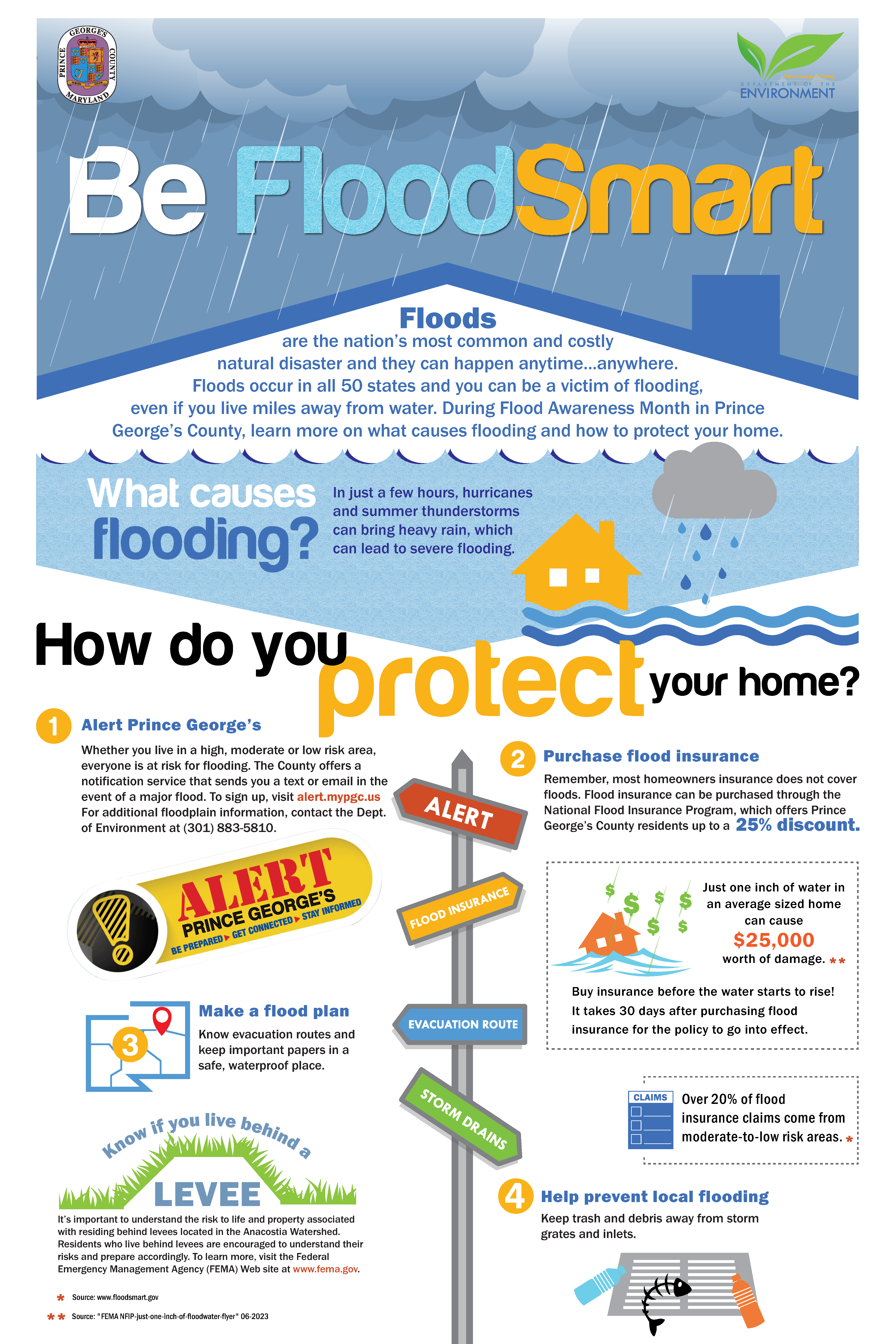
Be Flood Smart Virtual Educational Series
Last year, in observance of Flood Awareness Month, the Department of Education (DoE) hosted free virtual sessions to help residents prepare for the upcoming flooding and hurricane seasons. These sessions were equipped with information and resources to: improve understanding of how and where floods occur, share techniques and practical measures for flood risk reduction, and prepare for disaster response and recovery.
Session 1: Watershed and Flood Basics, Where Flooding Occurs
Session 2: Flood Risk Reduction Measures- Residential Drainage, Green Infrastructure, and Capital Improvement Projects
Session 3: Transfer Your Flood Risk, Purchase Flood Insurance
Session 4: Disaster Response and Recovery
Download and print a copy of the Flood Awareness poster here.
Floodplain Policy
The policy of the Prince George's County Government is to preserve the 100-year floodplain as a vital part of the natural system of a stream and to keep it in a natural state. This preservation aims to provide adequate storage for floodwaters and ensure sufficient capacity to move these waters downstream safely. When existing structures in the 100-year floodplain cannot be protected in an environmentally sensitive and cost-effective manner, the county may offer to acquire them to mitigate potential property damage and prevent obstruction of floodwaters.
Future development is regulated within the ultimate 100-year floodplain. Prince George's County utilizes ultimate land-use conditions and hydrology to determine flood discharges and generate flood elevations for areas of the county undergoing growth and development. Ultimate condition hydrology reflects projected land-use scenarios based on a community’s zoning maps and/or comprehensive land-use plans.
Prince George's County, through the Maryland-National Capital Park and Planning Commission, has established a policy to acquire stream valley parks throughout the county. This acquisition enables public ownership of the floodplain, thereby alleviating pressures for private development and providing recreational opportunities. Stream valley parks will continue to be a vital part of the county’s recreation, open space, and flood management programs.
Flood Management Goals
- Enhance the quality of life in Prince George's County.
- Prevent the development of future flood hazards.
- Provide expanded recreational and aesthetic opportunities in the county.
- Reduce or eliminate existing flood hazards.
- Mitigate economic losses associated with flooding events.
- Restore, preserve, and enhance environmental quality whenever possible.
Floodplain Ordinance
The Floodplain Ordinance was adopted by the County Council in April of 1989 and amended in 1993, 2000, 2011, and 2016. The Prince George's County Floodplain Ordinance is based on an ordinance proposed by the Maryland Department of the Environment (MDE). The Federal Emergency Management Agency (FEMA) contracted with MDE to review local floodplain ordinances to ensure that they met FEMA requirements for eligibility for flood insurance.
Read the Floodplain Ordinance here.
Filling/Construction in the Floodplain
The ordinance generally discourages filling or construction in the floodplain but allows for a variance under certain circumstances, such as when it is necessary to meet an important public need. When filling is required within the floodplain, an equal volume of compensatory storage must be provided. Furthermore, an impact study is needed to ensure that the floodplain elevation will not be increased. The ordinance also includes requirements for protecting buffers, wetlands, and other natural features associated with the floodplain.
National Flood Insurance Program
Prince George's County has participated in FEMA’s National Flood Insurance Program (NFIP) since 1972. The currently effective Flood Insurance Rate Map (FIRM) can be accessed by visiting the FEMA Floodplain Map for Prince George's County.
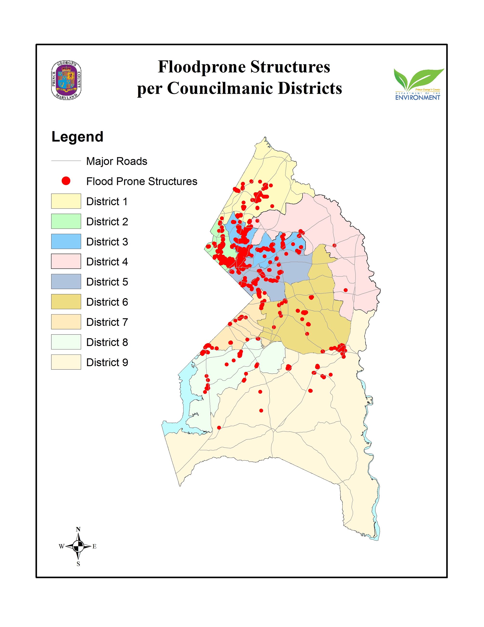
Known Flood-Prone Structures per Councilmanic District
Review a map showing the known flood-prone structures in the County.
-
Countywide Flood Damage Reduction Strategies
The multi-agency Stormwater Management Technical Group has completed a 15-year study effort to define the extent of the major flooding problems in the county. The study shows that approximately 4,000 structures are flood-prone in a 100-year storm event. Much of the flooding is concentrated in the older, highly urbanized inner beltway communities targeted for revitalization.
-
Elevation Certificates
Surveyors prepare elevation certificates and document the ground elevation, floor elevation, and general building characteristics for a structure in relation to the Base Flood Elevation.
-
FEMA Floodplain Maps and FEMA Revision
Download files with more information about the designated floodplain areas in Prince George's County.
-
Flood Insurance Rate Maps & Flood Insurance
Find flood insurance rate maps and other flood insurance information.
-
GIS & Mapping Components
Request in writing that a floodplain study be conducted by the county using GIS-based hydrology and hydraulic models, with the property boundary (lot/parcel) highlighted on a tax map, which indicates the area of interest.
-
Hurricane Season Special Warnings
The warm weather of summer brings with it the start of another change in weather, commonly known as “hurricane season." During the six months from June to November, the likelihood of hurricanes and tropical storms impacting the eastern United States is extremely high.
-
Local Flood Hazards, Mapping & History of Flooding
All waterways and bodies of water are susceptible to flooding—a condition that occurs when the volume of water exceeds the capacity of the waterway channels or when tidal waters are pushed inland by coastal storms.
-
Permitting
Qualified county staff are available at the Permit and Review Division to discuss your options and to help you plan and build a safe project while complying with the County Floodplain Management Ordinance.
-
Property Protection Projects
Learn about the county's property protection projects (retrofitting, drainage, protecting against high wind, etc.), and substantial improvement/damage.
-
Public Outreach
As part of its comprehensive floodplain management program, the county offers a range of services to residents and businesses.
-
Watershed Studies
The Stormwater Management Technical Group is an interagency technical group comprising representatives from the Department of the Environment and the Maryland-National Capital Park and Planning Commission, which was formed to study watersheds in the County. These technical studies include analysis of existing and planned land use, watershed hydrology, stream hydraulics, topographic analysis, evaluation of flood hazard mitigation alternatives, pollutant loading analysis, analysis of various water quality control techniques, and the National Pollutant Discharge Eliminate System (NPDES) Program.
-
Nuisance Flood Plan
Prince George’s County has approved Nuisance Flood Plan Phase I: Tidal Nuisance Flooding. This nuisance flood plan has been developed by the Prince George’s County Department of the Environment, Sustainability Division. Prince George’s County, like other jurisdictions, has its own unique needs, resources, and strategies that can be used to develop and implement a nuisance flood plan. The plan is being developed in two phases. This part of the plan is Phase 1. It includes background information on high-tide flooding, identifies impacted areas, and provides recommended actions. Phase 2 will build upon and expand this analysis to identify and track localized flood events, creating a more robust nuisance flood plan.